


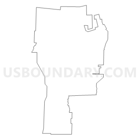
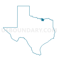
Voting District 0054, Grayson County, Texas
About
Outline
Summary
| Unique Area Identifier | 673433 |
| Name | Voting District 0054 |
| County | Grayson County |
| State | Texas |
| Area (square miles) | 53.44 |
| Land Area (square miles) | 53.31 |
| Water Area (square miles) | 0.13 |
| % of Land Area | 99.75 |
| % of Water Area | 0.25 |
| Latitude of the Internal Point | 33.54750890 |
| Longtitude of the Internal Point | -96.69979730 |
Maps

Graphs
Select a template below for downloading or customizing gragh for Voting District 0054, Grayson County, Texas


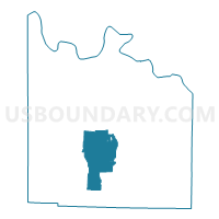
Neighbors
Neighoring Voting District (by Name) Neighboring Voting District on the Map
- Voting District 0003, Grayson County, TX
- Voting District 0008, Grayson County, TX
- Voting District 0009, Grayson County, TX
- Voting District 0027, Grayson County, TX
- Voting District 0028, Grayson County, TX
- Voting District 0031, Grayson County, TX
- Voting District 0033, Grayson County, TX
- Voting District 0035, Grayson County, TX
Top 10 Neighboring County Subdivision (by Population) Neighboring County Subdivision on the Map
- East Grayson CCD, Grayson County, TX (86,922)
- Northwest Grayson CCD, Grayson County, TX (23,440)
- Southwest Grayson CCD, Grayson County, TX (10,515)
Top 10 Neighboring Place (by Population) Neighboring Place on the Map
- Sherman city, TX (38,521)
- Howe town, TX (2,600)
- Gunter city, TX (1,498)
- Southmayd city, TX (992)
- Dorchester city, TX (148)
Top 10 Neighboring Unified School District (by Population) Neighboring Unified School District on the Map
- Sherman Independent School District, TX (41,508)
- Howe Independent School District, TX (4,871)
- S and S Consolidated Independent School District, TX (4,718)
- Gunter Independent School District, TX (2,955)
Top 10 Neighboring State Legislative District Lower Chamber (by Population) Neighboring State Legislative District Lower Chamber on the Map
Top 10 Neighboring State Legislative District Upper Chamber (by Population) Neighboring State Legislative District Upper Chamber on the Map
Top 10 Neighboring 111th Congressional District (by Population) Neighboring 111th Congressional District on the Map
Top 10 Neighboring Census Tract (by Population) Neighboring Census Tract on the Map
- Census Tract 19, Grayson County, TX (10,515)
- Census Tract 18.01, Grayson County, TX (6,016)
- Census Tract 17, Grayson County, TX (4,816)
- Census Tract 11.01, Grayson County, TX (4,196)